This hike was a lot of fun. I think getting there was half of it. Another very early morning. We've decided that hiking early is worth waking up early. You not only beat the heat, but you beat a lot of the other hikers as well.
Browns Peak:
- Length: 5 Miles
- Difficulty: Moderate to Saddle, Very Difficult from there to Summit
- Traffic: Light
- Est. Hiking Time: 4 Hours
We borrowed my dad's truck for the day, on account of the tough, rocky, steep roads that lead to the trailhead. The Four Peaks road is really a pretty rough road, and it was slow goings, even in a truck, but it was fun to drive. So after a two hour drive (a half hour on the freeway, and an hour and a half down the 20 mile dirt road) we made it to the trailhead, where it was a cool 70 degrees (we even saw a deer on the road as we were driving!). We laced up our shoes and hit the trail.
We kept a pretty solid pace as we made our way up the constantly ascending trail to Browns Saddle. The trail is beautiful. And such a drastic change from the desert down in the valley. There were pines and oaks and all kinds of green. It even smelled like we were in the forest and not the desert. We climbed over a few fallen trees, and squeezed through narrow parts of the trail where bushes crowded on each side. After about an hour we made it to the saddle. There were the most amazing views of the valley from the saddle. We could see all of Roosevelt Lake to the East, and ALL of the valley to the west. Our stop at the Saddle was brief though. It was overcast and we were wet with sweat and the wind was quite strong up there on the saddle; it was freezing!
So, in effort to get out of the wind, and to get an even better, more panoramic view, we continued up towards the summit. Before our hike, I was reading in my "guide book" about how the climb to the summit was "definitely not for the faint of heart" and how there was a "class-4 exposed climb near the top." I was pretty nervous. I even bought a rope and brought it with in my pack. As we neared the crevice/chute that we had to climb up, I even had some doubt as to if we would make it all the way. But we kept going. From the bottom of the chute, it seemed as if it was pretty much a vertical climb all the way up! But we kept going. It was little climb after little climb. We'd scale ten feet of rock and then there'd be another bit of trail to ascend, followed by another little climb. My watch read one hour and twenty-five minutes (1:25) when we got to the summit.

The view was amazing! I could see pretty much all of the valley that I've grown up knowing my whole life! There was Roosevelt Lake, The Salt River, The Superstitions, Saguaro Lake, The Beeline Highway, Red Mountain, Camelback Mountain, A Mountain, The Papago Buttes, The McDowell Mountains, Tempe Town Lake, and even a big white dot that was the University of Phoenix Stadium (I brought my binoculars to be able to see a few of these things). Though I couldn't see any of these things in great detail, it was still amazing how far the eye could see from atop Browns Peak. It was honestly, in my opinion, the most amazing view of the valley!

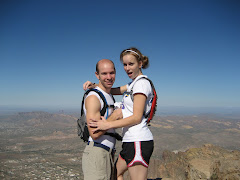
We took a twenty minute break there at the top, ate some granola bars, had the one other couple that was at the top take our picture, and then we headed down. Um... don't worry, we did not attempt to run down. At least not from there. It was a pretty slow climb coming back down from the summit until we reached the saddle. I would go first down a climb and then watch Shirley come down and tell her where the foot holds and hand holds were. And then we'd move on to the next climb, trying not to kick loose rocks and send them down the crevice towards the pair of hikers down below us.


Once we did reach the saddle, it was easy breezy from there. We jogged the rest of the way down. Took us and hour and fifteen minutes (1:15) from top to bottom. Though those narrow pathways where the bushed squeezed the trail turned out to be pretty vicious. They had little thorns on them that we didn't bother to avoid while running. You should see Shirley's scratched up legs.
To return, we took the dirt road that comes from the back (east) of the four peaks. It was much nicer and more accessible than the four peaks road coming from the beeline highway. Even our little car would've been able to make it if we would have come from that way (though i'm glad we had the truck; coming up the rough road was fun).
And we made it home in time to make the meatballs and the pie for our dinner company that night.
Great hike. Perhaps we'll do it again before winter gets here and snow tops the peaks.

No comments:
Post a Comment