Thursday, August 27, 2009
Phone Update
Monday, August 24, 2009
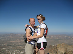
Aug. 15, 2009 - Camelback Mtn.
I imagine that most anyone who enjoys hiking, or even has friends that enjoy hiking, has probably climbed to the top of Mount Camelback (Camelback Mountain). I never had until I was 22. "Really?! I can't believe you've never hiked Camelback?!"

Well, I've done it a number of times since. Usually these days, it's with my wonderful wife Shirley. She is such a trooper. Shirley is wonderful and sweet and nice, but when we hike Camelback, she turns into this slave driving machine (I love you Shirley - I'm only exaggerating).
Shirley lived very near Camelback Mountain for a while, and has hiked/climbed/flown up and down the mountain quite a bit more than I. She has this habit when she hikes (and most especially when she hikes Camelback) of wanting to push the pace to the extreme. When we get on Camelback, she's racing the clock. Sometimes I think she forgets I'm there.
Here's a picture of Shirley making me eat her dust as she climbs this section past the first rail. Shirley calls these the "pansy poles" and mocks anyone who uses them. Do I use them? Sometimes. Does she mock me? Everytime. Even if I just accidentally brush up against one.
It's all in good fun though. Camelback is crowded; there are all kinds of people that hike it. I've even seen people going up barefoot (weirdos). But it's a great hike. It's close, it's challenging, and short enough that you can go hike it, and be back home on a saturday to get on with the rest of your day.
I think next time I'm gonna beat Shirley.
Friday, August 21, 2009
June 25th - 28th, Kernville, CA
 (not actually us in this picture)
Yeah, it's been a while. Like I've said before, I blog in spurts. Get excited about it one month, forget about it the next. But also, I feel lame-o writing about our awesome advetures, but without any thing to show of it (pictures).
But this trip was awesome. And I can swipe some pictures from facebook that others took.
At the end of June, we went to the tiny little tourist town of Kernville, CA for a white-water river rafting trip. Shirley had been rafting before but the closest I'd ever come to white-water rafting was floating the Salt River in a tube when I was a teenager.

We drove up wednesday after work. Got there around midnight. Found one of those pay campsites, but it was too late for any rangers to be there collecting money, so we camped. Woke up and left too early for any rangers to be there collecting fees yet, so we left. Met our group at the park in town, and headed for our camp site.
 For 3 days and two nights we camped near the river and went and ran different lengths of the river, taking extra cars and shuttling from put-in to take-out. It was loads of fun. At one point, the truck had taken off to pick up something and wasn't back yet, but we were anxious to get to the river, so we volunteered our car for the service. It coulda made it I think, but the truck got back just as we were about ready to go, so we let the truck haul the raft.
Apart from rafting there was a lot of other great stuff to do there too. When we weren't on the river, we did a lot of eating, a lot of hanging around telling stories, and even some hiking and rock climbing. We went on a hike up to a cave. It was pretty cool. Shirley whooped all our butts getting there. She's a trooper when hiking; didn't even turn around to see how far ahead of the rest of us she was. But the cave was cool. And I'd never been rock climbing outside of a rock gym, but the guys we were with had all the ropes and equipment, so we set up a couple climbs and went at it. It made me feel very cool climbing up the side of a cliff.
All in all it was a really cool trip. One I'd love to do again. Though, if I do go again, I'll remember to wear an older hat that I don't like as much. On one of the really big rapids, Shirley and got knocked down into the raft and when we bumped each other, off went my hat into the river - it got sucked under, never to be seen again... I liked that hat.
Sunday, June 21, 2009
June 20, 2009 - Hidden Valley Trail; South Mountain
So, today's hike was a neat one. Some parts were fun, and some parts were frustrating, but overall it was a neat hike.
I'd never hiked any of the trails at South Mountain; though as it turns out, there are a whole bunch. Today our plan was to go explore the Hidden Valley Trail. To get to it we were supposed to take the Mormon Trail to the National Trail, and the National Trail would take us to the Hidden Valley Trail.
Well, first of all, we slept in and then decided we would still hike, even though it was already 9:00. A little advice: Don't do this! It was SO hot by the time we got on the trail (10:00) and that aspect of the hike was NOT fun!
The other set back on this hike, and the frustrating part, was that we got off the trail we wanted to be on. You see, the route we wanted would have been 3.9 miles and was supposed to take 2 hours. We got off on a branch out trail and made a loop that added 3.3 miles, making our total hike 7.2 miles! We still finished it right at two hours though! Because we're bad.
Here's the map: If you can see it, we accidentally took the Mormon Loop off of the Mormon Trail and did that big loop to the right to get back to the Hidden Valley Trail. Phew. The beating sun sure made those extra miles not that enjoyable.
But:
I'd never hiked any of the trails at South Mountain; though as it turns out, there are a whole bunch. Today our plan was to go explore the Hidden Valley Trail. To get to it we were supposed to take the Mormon Trail to the National Trail, and the National Trail would take us to the Hidden Valley Trail.
Well, first of all, we slept in and then decided we would still hike, even though it was already 9:00. A little advice: Don't do this! It was SO hot by the time we got on the trail (10:00) and that aspect of the hike was NOT fun!
The other set back on this hike, and the frustrating part, was that we got off the trail we wanted to be on. You see, the route we wanted would have been 3.9 miles and was supposed to take 2 hours. We got off on a branch out trail and made a loop that added 3.3 miles, making our total hike 7.2 miles! We still finished it right at two hours though! Because we're bad.
Here's the map:
If you can see it, we accidentally took the Mormon Loop off of the Mormon Trail and did that big loop to the right to get back to the Hidden Valley Trail. Phew. The beating sun sure made those extra miles not that enjoyable.But:
 The Hidden Valley Trail was cool. A lot of hikers crawl all over South Mountain, but the Hidden Valley Trail was fairly secluded; we only saw three other hikers on that section of trail, so we were free to climb and explore and enjoy. And that part of the trail was a lot different than most the rest of the trails. There was this sweet rock tunnel:
And there was this sweet squeeze/crevice thing in the trail: They call it Fat Man's Pass. Can't imagine why it's called that, but i thought it was cool.
This is on the way back: There were pretty neat views of the city. You could see just about all of Phoenix, similar to last week's great view from the top of Brown's Peak except this was much closer than last week, so you could actually tell what things were down below you.
I recommend the Hidden Valley Trail hike. It was fun. It was neat. Just don't take the extra 3 mile loop during the middle of the day in the summer.
Monday, June 15, 2009
June 13th, 2009 - Browns Peak; Four Peaks, Tonto National Forest
This hike was a lot of fun. I think getting there was half of it. Another very early morning. We've decided that hiking early is worth waking up early. You not only beat the heat, but you beat a lot of the other hikers as well.
Browns Peak:
- Length: 5 Miles
- Difficulty: Moderate to Saddle, Very Difficult from there to Summit
- Traffic: Light
- Est. Hiking Time: 4 Hours
We borrowed my dad's truck for the day, on account of the tough, rocky, steep roads that lead to the trailhead. The Four Peaks road is really a pretty rough road, and it was slow goings, even in a truck, but it was fun to drive. So after a two hour drive (a half hour on the freeway, and an hour and a half down the 20 mile dirt road) we made it to the trailhead, where it was a cool 70 degrees (we even saw a deer on the road as we were driving!). We laced up our shoes and hit the trail.
We kept a pretty solid pace as we made our way up the constantly ascending trail to Browns Saddle. The trail is beautiful. And such a drastic change from the desert down in the valley. There were pines and oaks and all kinds of green. It even smelled like we were in the forest and not the desert. We climbed over a few fallen trees, and squeezed through narrow parts of the trail where bushes crowded on each side. After about an hour we made it to the saddle. There were the most amazing views of the valley from the saddle. We could see all of Roosevelt Lake to the East, and ALL of the valley to the west. Our stop at the Saddle was brief though. It was overcast and we were wet with sweat and the wind was quite strong up there on the saddle; it was freezing!
So, in effort to get out of the wind, and to get an even better, more panoramic view, we continued up towards the summit. Before our hike, I was reading in my "guide book" about how the climb to the summit was "definitely not for the faint of heart" and how there was a "class-4 exposed climb near the top." I was pretty nervous. I even bought a rope and brought it with in my pack. As we neared the crevice/chute that we had to climb up, I even had some doubt as to if we would make it all the way. But we kept going. From the bottom of the chute, it seemed as if it was pretty much a vertical climb all the way up! But we kept going. It was little climb after little climb. We'd scale ten feet of rock and then there'd be another bit of trail to ascend, followed by another little climb. My watch read one hour and twenty-five minutes (1:25) when we got to the summit.

The view was amazing! I could see pretty much all of the valley that I've grown up knowing my whole life! There was Roosevelt Lake, The Salt River, The Superstitions, Saguaro Lake, The Beeline Highway, Red Mountain, Camelback Mountain, A Mountain, The Papago Buttes, The McDowell Mountains, Tempe Town Lake, and even a big white dot that was the University of Phoenix Stadium (I brought my binoculars to be able to see a few of these things). Though I couldn't see any of these things in great detail, it was still amazing how far the eye could see from atop Browns Peak. It was honestly, in my opinion, the most amazing view of the valley!

We took a twenty minute break there at the top, ate some granola bars, had the one other couple that was at the top take our picture, and then we headed down. Um... don't worry, we did not attempt to run down. At least not from there. It was a pretty slow climb coming back down from the summit until we reached the saddle. I would go first down a climb and then watch Shirley come down and tell her where the foot holds and hand holds were. And then we'd move on to the next climb, trying not to kick loose rocks and send them down the crevice towards the pair of hikers down below us.


Once we did reach the saddle, it was easy breezy from there. We jogged the rest of the way down. Took us and hour and fifteen minutes (1:15) from top to bottom. Though those narrow pathways where the bushed squeezed the trail turned out to be pretty vicious. They had little thorns on them that we didn't bother to avoid while running. You should see Shirley's scratched up legs.
To return, we took the dirt road that comes from the back (east) of the four peaks. It was much nicer and more accessible than the four peaks road coming from the beeline highway. Even our little car would've been able to make it if we would have come from that way (though i'm glad we had the truck; coming up the rough road was fun).
And we made it home in time to make the meatballs and the pie for our dinner company that night.
Great hike. Perhaps we'll do it again before winter gets here and snow tops the peaks.
May 25th, 2009 - Fossil Springs, Strawberry, AZ
On Memorial Day this year, Shirley and I decided to head up north and check out the cool swimming holes down at Fossil Springs.
We woke up very early so that we could be at the trailhead in Strawberry just after 8:00. This because we had planned to be out and at a family party in Cave Creek at 4:00. So, after a stop at the Wal-Mart in Payson to buy some cheap water shoes, we got to the trailhead early, made a couple peanut butter sandwiches, threw them in the pack and headed down the trail.

Did I mention that Shirley and I like to run the downhills? According to my watch, we made it down in one hour and seven minutes (1:07). Though I don't think i stopped the clock for the break where i retied my shoes and Shirley clipped her too-long toenails. And I'm not even sure where I stopped it at down at the bottom. If you've ever been to Fossil Springs, you'll know that you can be at the bottom but not actually to where you want to stop.

The bottom is much, much different than I remember. Well, not because I remember it wrong, but they've changed it. The hydroelectric plant a few miles down stream from the springs has been out of use for years and they finally took out any remnant of such. The flume and the damn have both been removed. As a result, the water fall where the Dam used to be is much larger, but the swimming whole down beneath the dam is now too shallow and rough-watered to be much good for swimming. Also, due to the removal of the dam, all the swimming wholes above the dam are too shallow for any rope swinging or rock jumping. It was kinda sad. But we got down to the bottom, changed into our sweet water shoes and climbed in.
We marched up and down a couple little stretches of the creek and found the deepest of the pools to be a bit farther up stream, near where we came down at. I think the deepest spot there was probably 7 ft in the center. We played there for a bit, ate our sandwiches, dried off, and then headed back out. And this was the amazing part. According to my stopwatch, we came out in one hour and twenty-five minutes(1:25). But if I remember right, I started it farther in at the bottom than I had stopped my watch on the way in, and also, we stopped for five minutes to check out a frog at the bottom. But the thing is, we were definitely truckin up that trail. I don't think we even stopped once. Just kept hiking. It was amazing. I always call Shirley a slave driver when we're hiking uphill because she makes me go pretty fast.
And that was it! It wasn't a hike from my cool book, but It sure was a lot of fun... even without all the cool swimming holes that used to be. And, we even made it to the family party before all the food was gone.
May 2nd, 2009 - Peralta Trail; Superstition Wilderness
As i said before, the hikes in this book are common hikes, some of which I had even hiked before i got my hiking book. I won't make the effort to go back and be retroactive about accounting for all the hikes I've done in my life, but I will go back a little over a month and start with this hike:
The Peralta Trail
- Distance: 4.6 Miles
- Elevation Gain: 1,360 ft
- Difficulty: Moderate
- Traffic: Moderate-High
The night before, Shirley had talked about going running in the morning, well, by the time we got up after sleeping in and such, it was already past 9:00 if i remember, and Shirley didn't feel very much like going for a run anywhere around our place. She asked if we could go hiking.
Uh.... I was pretty sure there wasn't anywhere for hiking that was close enough to get to before the heat of the day set in, but i knew there were some trails off of the 60, out east past the valley. So we jumped on the freeway and headed east. I knew there was a turnoff for the Peralta Trail, though i didn't know what the road was like or how far it went back. We took it. The road was fine for our car, and from our place, it took us 45 minutes to get there. So away we went.
I remember that we got on the trail the same time as two other ladies. We were hiking right behind them and they could tell that we wanted to pass them, so they scooted over and let us pass, but warned us that we'd better run or they would catch us. Ha!
It was a great hike. I really enjoyed it. The superstition wilderness is amazing, and the hike itself wasn't too difficult. I was just afraid of the rattlesnakes. I think 3 (maybe 4) times, we passed hikers that were coming back that told us to watch the trail about five minutes ahead because they'd seen a rattlesnake on the trail. I was pretty scared. But we never actually did see the snakes.
We stopped when we got to Freemont Saddle (where most day hikers stop on this trail). There's a wonderful view of Weever's Needle there, as well as some fun rocks to climb around on the west side of the trail at the saddle. After a brief break, and after getting some fellow hikers to take our picture, we turned around and headed back.

Now, the reason we don't often invite friends to come with us on hikes (and Shirley will admit that it's more her than me) is that we like to cruise at a pretty brisk pace. Generally, on a hike, we hike the uphill and run the downhill. So I hope no one feels offended that we don't invite too many others to come hiking with us (though feel free to ask to come if you feel up to the challenge).
On the run down, about half way back, we passed the two ladies that we started with. They were still on their way up. Amateurs.
Sunday, June 14, 2009
The Resolution

About a month ago, Shirley and I were at the local Borders Bookstore just browsing and enjoying the evening when i stumbled across a most remarkable discovery... a book of course, called 60 Hikes Within 60 Miles: Phoenix by Charles Liu.
For $17.95, my life has changed.
This is my new favorite book. I recently started reading again. I'm not necessarily a reader, though I've read a number of novels on and off throughout my life. I read in spurts. I just finished Great Expectations and Life of Pi. Both were good, but this one tops all others, and it's not even a novel.
As the title suggests, the book outlines 60 different day hikes within 60 miles of Phoenix. I've always enjoyed hiking and since the time I met Shirley I've done even more of it because she enjoys it too! This book has motivated me to extend my enjoyment of hiking to more of a passion, if you will.
Most the hikes in the book are well-known hikes around the valley - hikes that I've heard of before, but his briefs and descriptions about each hike get me so excited to go out and attack the trails.
With each hike, He gives a brief of the hike, a short one to three page description, and then some key information about the hike, such as: length, elevation gain, difficulty, exposure to sun, hiking time, facilities available, and a bunch of other things.
Really, I'm so excited about this book that i decided to start a blog about the hiking experiences and that me and Shirley encounter! We've decided we're gonna do all 60 of these hikes!
And so it begins.
Subscribe to:
Comments (Atom)